Legacy Farms Overview
The Legacy Farms development considers and responds to the existing environmental conditions as well as opportunities inherent in the unique characteristics of this property. Divided by East Main Street (Route 135), the landform displays a variety of landscape characteristics from the gentle open terrain of the south side to the more dramatic rolling landscape of the north side.
The framework of the Master Plan builds upon the landscape character created by the interplay of existing resource areas and remaining landscapes with other portions of the property that have been disturbed by the nursery operations over time. This creates a public open space system that provides two important functions: connectivity between the proposed Legacy Farms neighborhoods and the surrounding context, and a means to frame and define these new neighborhoods. The logic of the historic nursery circulation patterns has also provided a road network rationale for Legacy Farms which uses portions of the pre-existing road system to create the main Legacy Farms Road, a secondary road network, and the system of public trails that will serve Legacy Farms and the Hopkinton community.
The primary gateway to the north and south sides will be west of the existing Weston Nurseries building at the intersection of East Main Street and Peach Street. The proposed Village Center is appropriately located to serve as a focal point with a mix of retail, restaurant, and office space, as well as a revitalized Weston Nurseries garden center.
Legacy Farms Road links the north and south development areas of Legacy Farms providing a direct connection from Clinton Street at the southeast corner to Rafferty Road at the northwest corner. This road will allow traffic headed for I-90, I-495 and the commuter station in Southborough to by-pass downtown Hopkinton, relieving congestion at the Main Street (Route 135), Cedar Street and Grove Street (Route. 85) intersection.
The Master Plan proposes a variety of residential types with an emphasis on 2 bedroom living styles. Single family homes are dispersed throughout the project, but are primarily adjacent to existing single family residential areas such as Curtis Road allowing for a smooth transition from these homes to the proposed Legacy Farms development. Throughout Legacy Farms, dwellings are framed by the public open space system and grouped in clusters around courtyards, greens and linear open spaces. To promote interaction many residential clusters will be connected by walks and / or trails, with the highest concentration of dwellings near the Village Center.
A more detailed description of the Legacy Farms built environment follows.
North Side
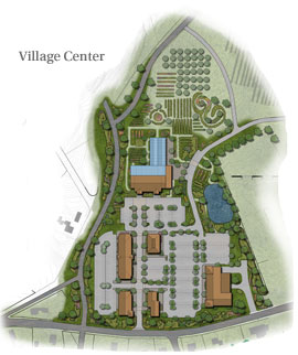
The Village Center
The existing Weston Nurseries Garden Center at East Main Street and Frankland Road occupies a gateway location and presents an opportunity to merge the plans of the Mezitt family with the vision for Legacy Farms. Plans for an up to date full service garden center, in combination with the Legacy Farms master planned mixed use community exemplify smart growth principles and sustainability. This plan offers the opportunity to create a Village Center which can serve as a focal point for Legacy Farms and the surrounding community.
The concept illustrates this potential synergy with a development program anchored by a new Weston Nurseries Garden Center, greenhouses and additional nursery areas located to the north. Additional uses may include a “green” or specialty grocer, a restaurant, and complementary small “boutique” retail shops organized along a wide, landscaped sidewalk which can serve as a main pedestrian way with areas for seating, seasonal plantings and other “village” furnishings.
The layout, scale and architecture of the Village Center will carefully orchestrate the appropriate New England character and charm, complemented with stone walls, extensive landscaping and tasteful signage.
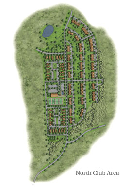
North Club Area
Arrival to this village will originate from a new way east of and parallel to Phipps Street. The new road will rise more gradually to the upper plateau through an existing slope. The road levels will provide access to the upper tier of the landform with portions of new village housing on either side.
Proposed street widths will be appropriately scaled and designed to enhance the pedestrian “feel”, and allow for on-street parking in some areas. A potential club house will serve as the focal point, provide a transition from the existing site grades and accommodate a variety of Legacy Farms community functions. Amenities planned for this area include a pool, tennis courts and a children's play area. Overlook parks are shown for the north and south ends of the plateau to serve as transitional spaces as well as public recreation. Pedestrian circulation is provided by a public walk system which follows the road pattern and connects the individual tiers to the club house area.
Dwelling types in this village will reflect the nature of the existing landscape. Homes at the upper level will enjoy sweeping panoramic views of the open flat plateau along Phipps Street. Similar views will also exist from higher portions of site areas to the west. These dwellings will be enhanced by views of the existing tiered levels that descend towards the east.
Small clusters of homes are proposed on the upper plateau between Phipps Street and the new Legacy Farms roadway. To preserve views from the highest portions of the property to the west, these will be predominantly one-story, with some two-story elements. The intent is to provide a varied roofscape that frames distant views. These dwellings will be oriented to small, intimate courtyards and gardens. Garages will be either attached or free standing depending upon site constraints, located to the rear to create privacy and served by an alley (or common drive). This alley system is designed to frame a common landscaped court while providing space for visitor parking. The front elevations of these buildings may have porches and other elements to enhance the pedestrian and residential experience.
The remaining homes in this North Club Area are proposed to take advantage of the existing tiered landscape, utilizing the downhill side to provide garage parking under the homes. The parking will be served by alleyways which provide for parallel guest parking on their outside edge. The nature of the tiered grading will allow uphill dwellings to overlook the buildings on the tier below, affording each tier the enjoyment of distant vistas.
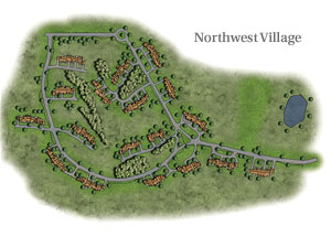
Northwest Village
This “hillside” village is located in the western portion of the north side. While the grade of this hill is not steep, its elevation is pronounced with sweeping views southwest towards downtown Hopkinton and east towards the Blue Hills. The landform is typical of the former nursery with open patterns and some groupings of larger, mature trees.
Buildings of attached homes, in one- and two-story levels, are proposed. These buildings will relate architecturally, appearing as single buildings reflective of a rural, pastoral character.
To preserve existing tree groupings and minimize grading, buildings will be located to maximize views and privacy as well. A number of the buildings may share common drives, minimizing driveways along Legacy Farms Road. The buildings are also situated such that an open space of restored meadow will meander behind and in front of the buildings reinforcing the sense of farm buildings in a field.
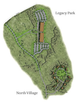
Legacy Park
Located at the northernmost corner of the property, Legacy Park provides an opportunity to attract niche users, drawn to the unique environment of Legacy Farms. A nearby example of this use is the Liberty Mutual facility located at the end of Frankland Road.
This site provides the appearance of a campus setting while being readily accessible to the regional highway system and commuter rail station in Southborough. The plan illustrates a potential office, life sciences or a mix of uses within the building sited at a gradient below Legacy Farms Road to be framed by an existing stand of mature trees. Parking is situated to allow uninterrupted landscape and views in front of and behind the building. The nature of this peripheral location within Legacy Farms may provide for a different architectural expression when compared to other areas within the site.
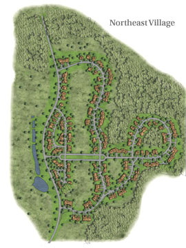
Northeast Village & North Village
This village is made up of residential dwellings located on the east side of Legacy Farms Road within an area that is predominantly open due to its prior nursery use. The land descends from the roadway to the east at a grade that ranges from four to twelve percent. Distant views are to the northeast.
Northeast Village housing types will be varied and are anticipated to include clusters of dwellings containing one- and two-story dwellings. The majority of the dwellings along Legacy Farms Road will be served by a rear alley (or common drive) to minimize curb cuts and garages along this thoroughfare. Responding to the existing nursery roads, the pattern of the built village and open land bays is aligned with a primary view corridor, which quickly gives way to a naturalistic looped road system. Due to the existing grade change, dwellings on the road look over the dwellings along the lower gradient which in turn look over dwellings further down slope. The placement of homes is orchestrated to create a flowing pattern of open space, the informal portion of which will be a restored, meandering meadow.
The Northeast Village roadway closes on a loop at the lowest portion of the village which frames an area of existing vegetation associated with a wetland. Buildings in this area are tucked in against the existing wooded edge.
This northernmost area (North Village) is situated in an area of existing woodlands with an understory dominated by mature rhododendrons. The land bay is gently sloped to the north and opens to a cleared meadow area in the center portion. Several existing nursery paths provide access to this meadow.
The dwelling types are shown as one- and two-story buildings with two car garages. Using the existing paths as a looped entry allows the preservation of green space with mature trees which ends at the roadway framing the existing clearing. Building sites are set within the wooded areas and at the edge of the clearing.
South Side
The south side topography is gently rolling and open. Views are predominantly internal and contained by existing wetlands vegetation at the southern periphery and off-site vegetation to the east and west. An existing pond in the southwest corner has been historically used for irrigation. This pond and the adjacent stream are planned as open space amenities for the south side.
Legacy Farms Road begins at Clinton Street and weaves its way through the landscape characterized by the existing land patterns of the former nursery operations. Utilizing existing wetland crossings, Legacy Farms Road turns to the north, intersecting with East Main Street just west of the proposed Village Center. Legacy Farms Road will connect the Legacy Farms villages of the north and south sides, providing a continuous link from Clinton Street to Rafferty Road, allowing traffic an alternative to negotiating Hopkinton Center and the intersections of Main (Route 135), Cedar and Grove Streets (Route 85).
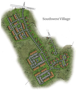
Southwest Village
The Southwest Village frames Legacy Farms Road as it turns towards the north to its intersection with East Main Street. This village is proposed to contain a variety of housing types.
To provide a transition to the existing Curtis Road single family homes, new single family homes with similar lot sizes will be located along the east side of Legacy Farms Road. A cluster of dwellings located on the west side provides a higher concentration within walking distance to the planned Village Center.
Apartment homes are proposed south of this area, separated by a buffer of existing wetlands and natural vegetation. The two- and three-story “garden” style buildings will be served by surface parking and have their own amenity area which may include a pool, small club house and play area. Across Legacy Farms Road to the east will be a cluster of homes. These buildings will be a mix of single and two-story dwellings each with a two car garage. The orientation of the garages to the street is varied to create a more interesting streetscape.
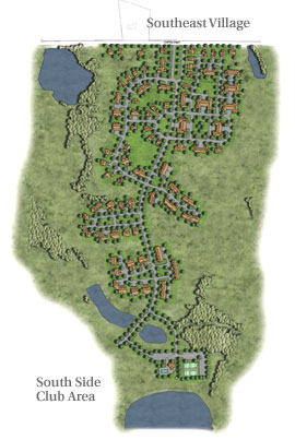
Southeast Village
This village, located on either side of Legacy Farms Road, will be comprised of clusters of homes framed by an undulating landscape of restored meadow and grassland. The clusters form their own internal and more formal open spaces. Single family homes are shown along Clinton Street to continue the scale and building/landscape relationship already present. These Clinton Street homes are anticipated to be of similar size to the existing homes on the street. Lot sizes are deliberately varied to allow for a more informal, flowing landscape of open space.
Within the village, homes will frame a landscaped entry court. This will be mixed with clusters on the north and south side.
To take advantage of existing topographic changes, two clusters are shown in the area to the west. The land in this location slopes away from Legacy Farms Road allowing garages to these buildings to be tucked under on the “downhill” side.
South Side Club Area
This proposed recreation area is located to take advantage of natural amenities such as the pond and stream in the southeast portion of the site. This area will accommodate a potential clubhouse, pool, tennis courts, and children's play area. In addition to parking for this facility, this area will also provide off-street parking to serve as a trail head for the public trail system of the south side.
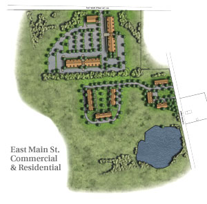
East Main Street Commercial and Residential Area
Residential and non-residential uses of the proposed developed portions of Legacy Farms share the same overall goal: to provide for a variety of opportunities in a manner that respects the scale and character of the existing landscape and built environment. The commercial area proposed for the parcel on the south side of East Main Street expands the small scale retail and office opportunities of Legacy Farms.
This commercial area proposes a mix of professional and medical office, retail uses and residential within an architectural style and scale that is compatible with its surrounding context. The overall configuration of the buildings will take advantage of existing wooded buffers to screen the area from adjacent new and existing residential uses.
The residential portion, located to the south, proposes a cluster around green areas. We foresee this as primarily two-stories to provide a transition from the commercial area to the lower density residential. It overlooks a large area of open space with a pond to the south and is framed by large pines to the southwest.